

- This event has passed.
NI Classic Championships 2025
Carntogher 1st November 2025
1 November, 2025 @ 10:00 – 15:00

Location (live map)
The 2025 Long Distance Championships will return to Carntogher mountain in the east Sperrins. The event is less than 1 hour from Belfast via the M2 / A6.
Although only a few miles from Glenshane Pass the terrain here is completely different and as you can see below it features a wealth of subtle contour detail. In addition to the natural features, the area has a network of unusual earthbanks which add landscape interest and linear features for the less technical courses. The east-facing slopes feature rich contour detail. This year the courses will visit some new areas of hillside and will all finish through some fields with interesting line features.

In recent years the local Community Association has been instrumental in establishing car parking, access, and walking trails which explore the history of this unique landscape and we will make good use of these for our event.
Getting There
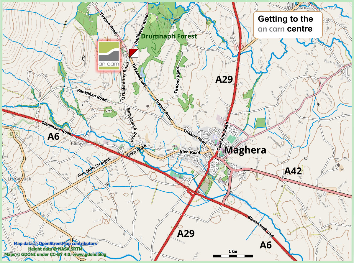
An Carn
132A Tirkane Road, Maghera, BT46 5NH
Parking
Parking will be at the An Carn Community Centre and Cafe. Please do not park directly in front of the centre (this is reserved for normal customers) and use the three areas shown on the map below.
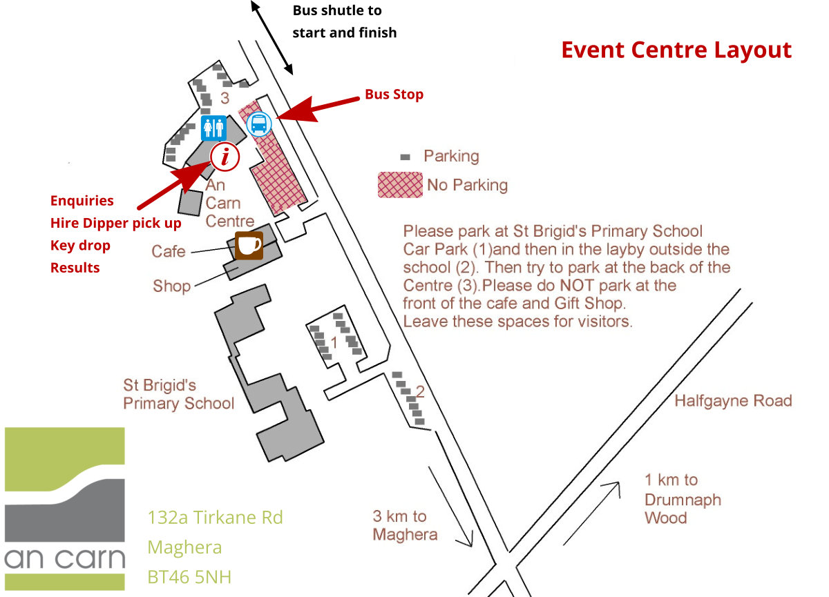
Enquiries
Enquiries, hire dipper pick up and car key drop will be at the An Carn Centre.
SI Air / Beacon Mode / Safety Controls
The controls will be SI Air enabled (beacon mode), but the start and finish must be punched in the traditional fashion.
A safety radio control (241) on courses 1-6 will track runners as they descend from the higher mountain section.
Bus Shuttle
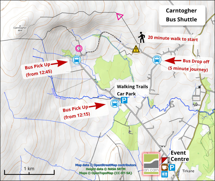
Bus to Start
A shuttle bus will take competitors to the start. This will leave adjacent to event enquiries. It will take 10 minutes to drive to the drop-off. There is then a further 20 minute uphill walk to the start.
Bus from Finish
From about 12:45 a bus will pick up runners 300m from the finish.
Runners finishing before this time may need to walk one mile to be picked up by the bus returning from the start drop off.
Weather / Safety
The start for all courses is at 800 feet (240m) and the area rises to over 1500 feet (460m). So low visibility, high winds and exposed conditions are possible. Should severe weather be forecast we will postpone the the event.
We will be requiring all competitors to carry / wear a cagoule. As it will be cold on the mountain some runners may also wish to carry a hat and gloves.
Whistles are also compulsory. There will be a small tent at the start.
Please read the map notes and hazards at the foot of the page. This is an unusual area and rock and water features require extra care.
Toilets
There are toilets in the An Carn Centre.
There are no dogs allowed anywhere on the competition area.
Start and Finish
First start 11:00 – last start 13:00.
Courses Close at 15:00.
Start Lists (now live)
Please try to keep to your start time if possible. However it is a punching start and we will aim to fit people in and and minimise competitor waiting time on the mountain.
Map
All courses will use a 1:10,000 map. This has been surveyed by Peel Land Surveys spring 2022 and updated summer 2025.
Course Details:
| Course | Length | Climb | Classes |
| 1 | 7.7 | 280m | M21L |
| 2 | 7.1 | 280m | M35, M40 |
| 3 | 6.3 | 260m | M45, M50, M20, M18, W21L |
| 4 | 5.7 | 210m | M55, M21S, M16, M60 |
| 5 | 4.6 | 210m | W20, W18, W35, W40 |
| 6 | 4.2 | 160m | M65, W45, W50 |
| 7 | 3.3 | 100m | M70, W55, W21S, W16, W60 |
| 8 | 3.2 | 100m | M75, W65, W70, Green |
| 9 | 2.3 | 60m | W75, M80, M85, M90, W80, W85, W90 |
| 10 | 2.8 | 100m | W14, M14, Light Green |
| 11 | 1.8 | 60m | M12, W12, Orange |
| 12 | 1.4 | 50m | M10, W10, Yellow |
Entries and Fees
Entries are now closed.
Enter Online- View Entry Lists
- Start Lists
- Juniors £12 (NIOA/BOF/IOA members £10)
- Full-time Students £12 (NIOA/BOF/IOA members £10)
- Seniors £25 (NIOA /BOF/IOA members £20)
- Family multiple individual runs £62 (NIOA /BOF/IOA members £50)
Yellow, Orange, Light Green, and Green colour courses are also available. These are pre-entry only.
Mapping Notes
The higher areas of Carntogher has many old peat cuttings which in places is complex. To best represent this the mapper has modified the steep bank symbol by reducing the length of the tags and in places removing the tags all together. In the terrain these are most commonly a 1m drop and fairly easy to cross, though in places they are even smaller than this but always distinct features in the terrain. Sometimes the cuttings face each other and are too close to map so here the wet ditch symbol has been used to represent the line of cuttings. However in other locations the symbol can be a traditional ditch often with flowing water.
There are many patches of gorse across the area and in most cases these have been shown as Vegetation Fight but occasionally when younger Vegetation Walk. Only the most distinct trees and bushes are represented.
Knoll symbols are used to indicate not only very small hills as we would expect in Ireland, but also to indicate high points on hills.
The unusual geology/hydrology of the area results in water channels cutting below the surface vegetation in places. This makes small streams more difficult to see and indeed you may hear water courses (or linear marshes) before you see them! Extra care is required.
The marsh symbol tends to be a better guide to vegetation type than the actual wetness of the ground. By Irish mountain standards, the area is relatively dry (probably because of the unusual hydrology mentioned above).
Planning Notes
We are using a high start which is up a track to the east of the map. This will provide all competitors with some new terrain but will also reduce the climb for courses 9 – 12. A minibus will transport all competitors towards the start but there will be a 20 minute walk uphill to the start from the drop off point. The start has been selected to suit courses but is awkward for the organising team. Please arrive on time and co-operate with the officials.
Courses 1 – 8 will get over to the complex terrain on the west of the map. This area is covered in stone and rock. We have decided that it is safer for competitors to climb up this area rather than run down through it. This will result in some climb on all these courses towards the end of your course.
Courses have been planned slightly shorter than normal to allow for the climb. Thank you for supporting our event. We hope you enjoy your run.
Cafe / Shop
There is a good cafe in the An Carn Centre providing meals, snacks and coffee. There is also a shop with a range of hand crafted goods. Please support these community enterprises.
Prize Giving
This will be in the An Carn Centre as close to 3pm as possible.
Dogs
No dogs are allowed in the competition area.
Hazards
- The area is open, exposed and mountainous. You must bring a cagoule and carry or wear it throughout the event.
- Some of the faster hillside areas contain many small rocks. Please exercise care, particularly while descending.
- Most of the competition area is over 800 feet so low visibility is very possible. Ensure you carry a compass and be prepared to lose height to the south should you need to retire.
- Be aware that the unusual hydrology of the area results in some small sinkholes and linear trenches forming in the surface peat.
- Whistles must be carried.
All participants take part at their own risk and are responsible for their own safety
Event Query
Officials
- Organiser: Ruth Blair
- Controller: Des Fletcher
- Planner: Anthony McGonigle